section-cb4e408
section-74cb86c
An initiative of the South Bracebridge Environmental Protection Group inc., Protect Muskoka provides a platform for broader public discussion on smart land-use planning and its social impacts. Prior to it being formed, few in the community were aware of the request to amend the Official Plan and also rezone 443 acres of sensitive wetlands by the developer of Muskoka Royale College (MRC).
The challenges facing our town and our next generations should be decided with community involvement. With climate change and ecological destruction everywhere, infrastructure and broader community issues at stake, public education and discussion about this development and land use has never been more important.
The challenges facing our town and our next generations should be decided with community involvement. With climate change and ecological destruction everywhere, infrastructure and broader community issues at stake, public education and discussion about this development and land use has never been more important.
Protect Muskoka is now supported by thousands of voices in Bracebridge and the Muskoka District with respect to the rezoning request by Muskoka Royale College, and it will continue to keep this community informed on its status.
Learn more about us at www.letsprotectmuskoka.ca and www.BracebridgeWetlands.ca
Muskoka Royale College is a private international boarding school development proposed to be built on 443 acres of a sensitive wetlands complex in the Town of Bracebridge. This proposed development is the same size as downtown Bracebridge.
The project includes a secondary school for 1,200 students and 116 staff, an elementary school for 600 students, dormitories for 600 secondary students and 300 elementary students and 30 staff apartments, a recreational complex, office buildings, maintenance facilities, parking lots and access roads. During the summer (June, July and August) when the school is not in session, the facilities are planned to be used as a summer camp with a total of 1800 campers.
This development will change our community forever and for the worse.
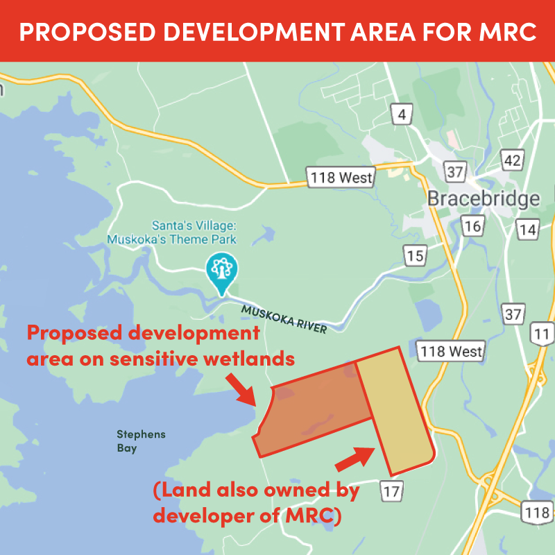
Muskoka Royale College is slated to be built on an L-shaped 443-acre tract of land that sits just off Stephens Bay, with Stephens Bay Road and Stagecoach Road to the west, Muskoka Road 118 West to the east and part of the property stretches to Muskoka Beach Road to the south. To the north, it doesn’t quite reach the Muskoka River. The proposed development area is as large as downtown Bracebridge.
The 443 wetlands impacted include Henry Marsh.
Once complete, the school is expected to host upwards of 1,800 students plus an estimated 200 faculty, administrative, maintenance, catering and housekeeping staff. During the summer (June, July and August) when the school is not in session, the facilities are planned to be used as a summer camp with a total of 1800 campers.
Kirby Beach and Golden Beach are the closest public access points to the school. In addition to organized outings, 2,000 more people will use these beaches, hiking and biking trails, parks and other public spaces during their personal time. A 12.5 per cent increase in population will have an adverse impact on our quality of life and the amenities we all enjoy.
Despite public protest for additional studies the Town Council approved the rezoning application and the District of Muskoka approved the Official Plan Amendment. As there is currently an appeal to the Ontario Land Tribunal - OLT (formerly the Land Planning Appeal Tribunal - LPAT) by a citizen's group this development is on hold pending a decision at the September 2022 hearing which is scheduled for 23 days.
The existence of this facility will re-activate a push for the Western Bypass, diverting traffic from the downtown core. This will severely impact the stores and businesses that rely on this traffic for their customers.
The tallest building in the proposed project will be four storeys high and built on a ridge, which will make it higher than any building in Muskoka. This eyesore will be visible both from local roads and neighbourhoods and from the Lake. The lighted outdoor facilities will hide the night skies and destroy the night views from the lake.
Yes. This will have a significant impact on taxpayer-supported services and amenities. It will put pressure on our landfill, water, sewer and other services that will be paid for by local taxpayers.
When downtown businesses close because the Highway 118 bypass takes all traffic out of the downtown, who will make up lost commercial taxes? Unfortunately, the remaining taxpayers in Bracebridge.
There will be modifications to both. Instead of enjoying Henry Marsh while on the trail, you will be looking at institutional buildings.
Claims that the developer is working with the Muskoka Conservancy to preserve the wetlands are false. The Conservancy approached the developer about protecting Henry Marsh and the requests were rejected.
Shockingly, Henry Marsh has been drained twice by people and of course without permission. Twice the Muskoka Field Naturalists restored it. Given this, how can we trust any assurances or that processes will be followed as the Town of Bracebridge Council and the District of Muskoka give the developer the green light.
Not properly. The developer conducted an Environmental Impact Study using outdated data and old science. Its findings were misleading and incorrect.
The South Bracebridge Environmental Protection Group conducted its own Environmental Impact Study that completely discredited the developer’s report. Following this discredited report, the Town Council ordered another independent study which again, discredited the developer’s report. Yet the developer is publicly claiming that environmental standards have been met. This is not true as the town’s own study shows.
How can Town Council move forward on this basis?
How can they or we trust any claims being made about this development when we are being misled on this critical issue?
It also found that 204 species live in this area, and identified it as an area where fish spawn and birds nest.
The Ontario government says local planning authorities should ensure that a wetland evaluation is completed if it shows characteristics that would make it significant — that is, supports at-risk species or performs special functions. An Ontario Wetlands Evaluation System (OWES) assessment has yet to be completed on this property. An OWES will properly map and assess the importance of the wetland complex and determine if it is Provincially Significant and worthy of protection.
At the very least, Town Council should order an OWES before anything proceeds further.
It has not been officially designated as such because an OWES assessment has not been completed on it. But consider what multiple environmental studies have been found on this land:
- There are 204 species documented to be living on this property.
- 20 of these are species at risk.
- Seven species — Blanding’s Turtle, eastern hog-nosed snake, barn swallow, bobolink, eastern meadowlark, least bitterns and bank swallows — are endangered according to the Endangered Species Act of Ontario.
- This wetland complex is a buffer protecting Bracebridge and Lake Muskoka from flooding and has many tributaries including one that flows from Henry Marsh with an outlet into the Muskoka River. The Beaumont Wetland Complex is fed from an underground water source flowing from an aquifer at the Muskoka Watershed of which the Muskoka Field Naturalists have been involved for many, many years in its protection.
- It is an area known for nesting turkey vultures, spawning fish and wintering deer.
- There are 298 native plant species on the property.